(Photos by Brain Fabel/NOLS)
I recently participated in a Leadership Navigation Challenge, which was developed and offered by the National Outdoor Leadership School.
The National Outdoor Leadership School – also referred to as NOLS – is headquartered in my hometown of Lander, WY. I was raised in Lander, and I think my only regret in life is that I have never taken a NOLS course. Participating in the Oct. 9 Leadership Navigation Challenge, although only a few hours long, would be a start for me, and I was pretty excited about the opportunity.
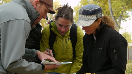
I want to become a better leader. The NOLS website says the Leadership Navigation Challenge focuses on the core aspects of NOLS’ leadership training in a format that is hands-on, fun, and effective… This condensed expedition mimics challenges that teams face anywhere: making expedient decisions, balancing task achievement with group development, blending distinct individuals to form a cohesive team, and working through unforeseen hurdles.
This is a good time for me to point out that in my travels throughout the U. S., I have many a time met a leader in an industry that after getting to know him/her reveals he/she has taken a NOLS course at some point in his/her life. This happens often, and always, these people are leaders. I just can’t believe that’s an accident. In addition to many other corporations and organizations, NASA and Google are regular clients for NOLS’ Professional Training. (For more information, learn about the various Professional Training programs offered by NOLS.)
I reported to City Park at 1:30 pm on Oct. 9 under a damp and gray Autumn sky.
Participants were divided into groups of four and two facilitators were assigned to each group. Our facilitators were Kat Smithhammer, NOLS Professional Training Program Coordinator from Victor, ID, and Jaret Slipp, NOLS’ Yukon director.
Have any of you ever seen the reality travel show called The Amazing Race? This is how I would describe some of the moments in our experience, only minus the drama. We were collaborating and working together as we were “racing” quickly to find the next cache and to hopefully beat the the other teams to it, while also racing against the clock. Suffice it to say that this was a pretty exciting adventure from the start.
For this particular exercise, we were given a GPS (global positioning system), along with a packet containing a detailed accounting of about 25 caches to locate throughout the town of Lander, including GPS coordinates for each, point value for each, as well as thumbnail photos that provided visual hints of each “target”/cache.
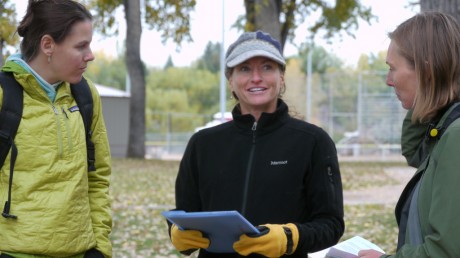
There were two kinds of caches, physical and virtual.
Physical caches describe those where we located the target (thanks to a photo hint and GPS coordinates we had on hand, and then after locating the target, the cache would be within 12 feet of the target. Physical caches were little plastic containers that held three paper tickets, one green (most points), one pink (second-most points) and one white (the least amount of points). The fourth/last team to discover that cache was to simply “clean up” (take the container, but get no points).
Virtual caches describe those where we located the target (illustrated via a small photo and GPS coordinates), then answer a question provided with the photo. Hints and clues to the answer were to be observed near the target.
We started the experience at 1:30 and were instructed that we had to return to the gazebo at City Park by 3:30. Any teams arriving later than that would be automatically disqualified. So instantly, we realized that our return was more important than getting all the caches (if we couldn’t achieve both.)
I acknowledged to my team from the start that I’m not the best at “finding my way” if there’s not a trail or defined path. I told my teammates that I was not qualified when it comes to route-finding using a GPS. Turns out I wasn’t the only one without good GPS experience. No problem, though. Rob Bethge, one of our team members, offered to be responsible for the GPS and attended a quick pre-exercise learning session about the device.
Still, options are good, and we had some. We could choose to spend (future) points to purchase additional information that would help us in our quest. We took advantage of this option and spent 1,500 points to get a Google Earth map printout that had the caches plotted on a map.
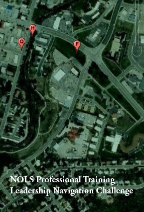
That decision was huge. Being a long-time Lander resident, I know the town pretty well and suddenly we had a visual of all the cache locations. I think this helped all of us in determining a strategy.
After the instructions and a quick review of the our packet of information, our team strategized.
Should we try to get them all and start with the one closest to us geographically and work our way around? Should we head out and get the ones that are farthest away first then work our way back? Should we identify in advance which ones hold the most point value and only go for those? Should we “cluster” them according to location and proceed that way?
The latter was Rob’s suggestion and we all agreed that was a sound strategy. So off we went with our strategy, our objective, our hints, our trusty GPS, our map printout — and each other.
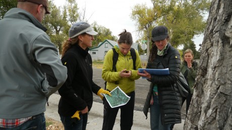
Well it wasn’t long and we modified our strategy. As we made our way down S. 5th Street, we noted on our map printout that there were a handful of caches not too far from our path. We surmised that, despite the fact they were not located in the far cluster we had originally set our sights on, it might make sense to pick those up now so there wouldn’t be any unnecessary back-tracking later.
Turns out, it was only a minute or so later that we found our first target: A wagon wheel in someone’s yard near the sidewalk we were on. It was exciting!
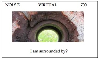
It was a “virtual” cache. The wagon wheel’s center matched the photo hint that was provided in our packet. (See photo below) To get points we had to correctly answer the following: “I am surrounded by_____.” We quickly jotted down “spokes,” and were on our way.
From there, we went another block or two out of the way to be the first to locate a physical cache near a utility pole that had a license plate on it with a number and symbol that matched the photo hint in our packet. About four feet away we found a little plastic container with the tabs in it. We were the first there so collected the most valuable one, the blue one, and went on our way. A couple blocks later, off an alley, we found our second physical cache, and again we were the first to find it.
We were off to a great start. I would say we were cranking. I found it exhilarating for our team to find the early caches, especially to be the first team to find them. These early successes provided instant gratification and served as a confidence booster.
We also had finished in pretty good style/time our first team challenge which involved us holding a tent support on our two index fingers and as a team lowering it almost to the ground without the extended tent pole ever leaving any of our index fingers.
We were walking briskly and at times even jogging. At this point I had no complaints and I think our whole team was feeling pretty confident and “in the running.” Dare I say, we were in the “flow.”
Unfortunately, it was short-lived.
It all changed with our second team challenge, which was worth 2,500 points. A big one with a lot at stake. A lot to potentially gain; a lot to potentially lose.
Enter one of those wooden puzzles that as kids we’ve all seen and tried — basically a square frame/base that measured approximately 7″ x 7″ and contained geometric puzzle pieces. To be exact we had 2 big triangles, 2 small triangles, a parallelogram and a square. And darn it if we couldn’t figure it out!
Time was ticking as we all took stabs at it, but to no avail.
At this point, I began to feel anxious. The confidence I had for our team was slipping. I’m guessing that what felt like an eternity as we struggled at the puzzle was five or six minutes. We were losing time and had nothing to show for it.
The others, I’m sure by their nonverbal gestures, were feeling the same anxiety. It was at this juncture that we had the important question to address: With so many points at stake and having invested a significant chunk of time already, at what point do we scrap this and try to make up for time and points? This is no easy question to answer. We all knew we could be seconds from solving the puzzle and gaining 2,500 points (not to mention fruits for our labor). We also all knew we could keep struggling, spending time that was dwindling, and still get zero points if unsuccessful.
If that wasn’t challenging enough, it was at this point that our facilitators, Kat and Jaret, instructed us to spend 2 minutes being completely quiet, for “reflection.” After that, we’d have 2 minutes of “sharing.”
This was hard! We had just spent a significant amount of time and effort on a challenge that was worth a lot of points, without success, and now we were being forced to take another four minutes, during which we would not be discovering caches and/or racking up points.
In hindsight, this was a brilliant time for such forced silence and reflection.
For the record, I’m not good at living in the present. This continues to be one of my biggest personal challenges. I have a lot of energy and ambition, and am a planner who is always looking ahead. I’m not good at stopping and “reflecting.” So this in itself was quite a challenge — and with no points attached, I might add!
Interestingly, after the silent reflection, Lou wanted to take another stab at the puzzle. Wow. I can tell you trying the puzzle again didn’t occur to me once during my own quiet time. I had had enough of that puzzle. Instead, I had focused on how we would be able to get to the most targets, holding the most points, in the shortest amount of time.
Unfortunately we did not solve the wooden puzzle, and we all agreed rather quickly that we should identify the most valuable caches that were “within our reach” with respect to our current location and the remaining available time. (At this point, because I am familiar with Lander, I knew we were about .6 or .7 miles from our “finish line.”) We did a quick review of remaining caches in our vicinity and agreed to forego any that were of little value or too far out of the way.
Fortunately, we were able to locate and collect points for a couple more caches en route back to City Park. But we didn’t hit a home run. The second-to-last cache we discovered was a virtual one and for the life of us we could not figure out the answer. The photo hint looked like a piece of chipped paint the shape of a maple leaf, but much, much smaller. The question we had to answer, whose clues would be evident near the target, was “What state is to the south?” Hmmm. This one was a head scratcher for us. After walking down and then back to the street’s mid-way point the only thing we could find that had anything remotely resembling the hint in the photo was a manhole covered with scrapes and little marks with various shapes.
Most significant about the manhole was it had printed on it, “Wisc.” We thought we hit the bulls’ eye on the target. The big debate was in determining the answer to the question. We wondered, is Wisconsin the answer, or is the correct answer the state that is south of Wisconsin (Illinois)? We argued in a friendly manner before settling on Wisconsin.
The last cache we tried to “win” was in City Park. We figured we’d get some more points right at the finish. Er, it was the most difficult one yet. We didn’t even have a guess at what the answer was.
Another valuable aspect of the experience was our debriefing at the end. As a team, our facilitators asked us to offer input and observation about our individual experiences as well as our team’s. Some really interesting and useful insights were shared during this activity.
The Leadership Navigation Challenge was a terrific experience. I know I have described it like a GPS scavenger hunt. And that, it was. I also make it sound like it was fun. And was it ever!
However, the fun GPS scavenger hunt facilitated far more important activities. Namely, it was an afternoon of working on leadership skills. At various times, our team collaborated, built consensus and strategized. There were times for each of us to follow and for each of us to lead. At times one of us was more decisive than others and that initiative was helpful. Fortunately we worked like a team, at times like a well-oiled machine, even.
I can think of ways that my experience and learnings during the NOLS leadership experience will help me in my work (and life) in the future.
One thing I was well aware of is prior to my participating in the NOLS Leadership Challenge is that I prefer to lead, and am not super experienced at following. In fact some of my friends even (lovingly) don’t think I’m capable of following. Well, despite thinking of myself as a natural leader, I was made almost immediately uncomfortable with the notion of “leading” from the start of Saturday’s event.
I have no experience using a GPS and am not a person who is experienced when it comes to navigation. So in addition to not feeling like leading, I also felt pretty insecure, which is another feeling I’m not too accustomed to having. What I learned from the start of the Challenge, and at various times throughout the Challenge, is that often another person or persons will step up and take initiative and that I can do better to let them. I actually learned that I can effectively follow, as well as a leader might be one that follows at particular times.
This is not a small deal for me, and I can already imagine instances in my work where I will be better at following and letting others take initiative and leadership in decisions, roles, and other instances.
I also learned that there can be many leaders on a team – that leadership doesn’t necessarily refer to a single person or a “standout performer.” Our team during the NOLS Leadership Navigation Challenge had four members on it, and I would say throughout the challenge, each of us took initiative and led strategy, direction and decision-making at one time or another.
In other words, having more than one leader, or strong member of a team, doesn’t necessarily translate into competition or inaction or poor teamwork as a result of egos or in-fighting. This, too, will be valuable for me, particularly the next time I’m working with a team on a marketing campaign or product innovation or selecting people with whom to start a business. It’s possible for there to be multiple leaders and that there can be still be success and forward progress with more than one leader on the team, and/or leadership being distributed across multiple members of the team.
As a bonus, here is a very short video composite of my experience. (Thanks to Brian Fabel/NOLS for the video production and permission for me to use)
NOLS’ Leadership Navigation Challenge – 2 minute recap from Brian Fabel on Vimeo.
ADDITIONAL INFORMATION:
NOLS PROFESSIONAL TRAINING
Call 800-710-6657, x. 3
