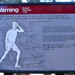
The first sign is right at the start of the South Kaibab Trail: WARNING: Do not attempt to hike to the bottom of the Canyon and back in a single day. The signs are numerous, and for good reason.
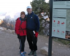
We had seen them all before, though, 10 years earlier when we had embarked down the trail, and despite their warnings, had survived to tell about it.
You see, my parents had agreed to meet up with us for the Grand Canyon part of our Spring Break. They rented an RV for the first time and the plan was they’d watch our boys on Tuesday, April 7, while Jerry and I attempted to hike the South Kaibab Trail to the Colorado River and Phantom Ranch (at the Grand Canyon’s bottom) and back out via the Bright Angel Trail. We were pretty certain that we were not in as good of condition as we were the last time we did this. After all that was before we had kids and during a time when we were training for our first 50k trail run. Still, given the fact my parents would be there to watch the boys, we couldn’t resist the opportunity.
My dad was a trooper and awoke with us at dark thirty to drive us to the Bright Angel Lodge where we’d take the first hiker shuttle of the day, set to pick us up at 6 am. We’re early risers so this wasn’t a big deal. In fact it felt like sleeping in for us.
In the dark we swigged coffee while riding the shuttle to the trailhead.
It was beautiful out. The almost-full moon was still visible, and as we started down the trail in front of a few other hikers, I could tell it was going to be an epic day.
The biggest challenge about this hike isn’t the distance, although it’s long for a day hike. Certainly the elevation gain and loss is a huge challenge. We would descend 4,700 feet, and ascend 4,700 feet, all in a single day. Still, the elevation gain and loss is not the hardest part.
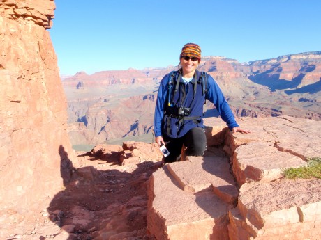
The problem with this hike is you go down, and then you go up.
I live in western Wyoming. Mountain country. Every hike I take heads up first, then down. I’ve grown accustomed to working first then getting the reward. Hiking up in the morning, down in the afternoon.
Hiking to the depths of the Grand Canyon and out is the exact opposite. I know: Duh, it’s a canyon, not to mention a big, deep one. But it’s important to mention this because if you do this single day endeavor, there’s almost no way to avoid walking up hill during the heat of the day and on tired legs.
Here are a couple of short videos that show some of the trail:
So, while hiking down the South Kaibab Trail at a fast clip we were very much aware that what goes down certainly must go up. The South Kaibab Trail begins near Yaki Point on Desert View Drive. The first mile takes hikers down more than 1,000 feet and 1.5 miles to Cedar Ridge, where great views surround you, and a bathroom is available. The next 1.5 miles drops another 1,000 feet to Skeleton Point.
We took a gazillion photos and video clips on the way down and made some brief stops to let mules pass, as well as to strip layers as it became warmer as the sun rose and we dropped to lower elevations. In a little over three hours we were crossing the Black Bridge across the Colorado River, at 2,400 feet elevation. In all, we dropped about 4,600 feet on the South Kaibab Trail.
At that point all we could think of was the Snickers bar and lemonade that awaited each of us at the Phantom Ranch Canteen. But it was about another half mile or so before we could reap that reward. The Snickers and lemonade met our expectations and before we knew it we were back on the trail by 10:30 am.
We stopped on Silver Bridge to watch the huge volume of water rush by below us and to watch a few groups of rafters navigate their way down the green Colorado River. Boy, that looked refreshing. (Note to self: Figure out how to experience a rafting trip without having to wait a decade)
Bright Angel Trail is the most heavily-used trail on the South Rim of the Grand Canyon.
The bottom of the Bright Angel Trail starts out as a mellow trail that parallels the river for a mile or two before changing its mood and rising more steeply. Still, for the first half of it’s 9.6-mile distance from Phantom Ranch, it’s a pretty reasonable grade.
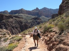
About halfway up, near Indian Gardens, it gets a personality that’s wicked and unfriendly if not downright mean. After Indian Garden, it becomes a stairmaster for five miles. (If you must know, you still have 3,000 feet of vertical to hike up – in just 4.6 miles)
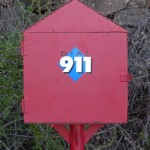
Probably the cruelest part of the trail is when you reach the “3 mile house.” At this point you can see the teeny, teeny people standing on the Trailview Overlook waaaaayyy up above you and you are reminded in an “in your face” way the vertical distance you still have to travel. (Again, if you must know, there are still 2,000 feet of vertical to hike up.) It’s no accident – or joke – that there is a 911 call box on the side of the trail at this point.
The last three miles up Bright Angel are truly a course in character (and calf muscle!) building. Unless you hiked down in the wee early morning hours of the day and you’re a rapid hiker, you’ll be hiking this vertically-oriented section of Bright Angel in broad daylight and under the heat of the sun. Fortunately there is some reprieve from the sun against the rock walls.
And try as you might, you can see that there is clearly no other way up/out. It’s humbling to say the least. The sun was in full, not a cloud in the sky and we had hours and miles on our feet. We weren’t skipping anymore, and the smiles on our faces in the photos we snapped probably weren’t natural, if you get my drift.
Here’s a sampling:
The trail switches for a long distance, and of course you can see the switchbacks, which are not friendly ones. They are steep and seemingly never-ending. The scale of the Canyon’s rim towering over the trail is enormous. Hikers resemble ants, with their day packs or backpacks upon them, and appearing to be moving at a snail’s pace in a march up the mountain. A death march perhaps?
People hiking up at this point in the trail, regardless of where they’ve come from or how many miles are on their legs for the day, seldom say much. On the other hand, hikers descending the trail are giddy and skipping and seemingly oblivious to how the return trip is going to treat them.
Finally, we made it to the top. It took us a little over 9 hours. That includes several very short stops, mostly to take photos or to capture videos.
We don’t recommend this single day hike for people who are not used to hiking up and down mountains or for those who can’t take the heat. I would never recommend this during the summer, and in fact wonder how anyone could do it, or better yet, why anyone would choose to.
All that said, this hike remains one of our favorites. It’s a huge accomplishment to think at the end of the day that we started at the top and walked on our own two feet all the way down, across the Colorado and back up. Certainly it was a physical accomplishment, but also a mental one.
The Grand Canyon is one of the most studied geological landscapes in the world. It offers a record of three of the four eras of geological time. To walk down into and through this exposed and massive land erosion is quite the unique experience. I felt tiny and insignificant in the spectrum of time as I took in the great abyss that surrounded us.
To be sure, the aforementioned hike provides an interior view of the Grand Canyon that is unmatched.
Here is an 8-minute video that pretty much covers the entire hike: